What do dunes mean to Michigan? Latest research from CSUS faculty explores perceptions of coastal sand dunes
 Print
Print Email
EmailMSU researchers now understand the range of public perceptions and knowledge about Michigan’s coastal dunes.
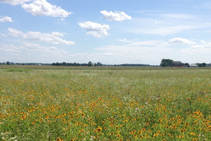
For many Michigan residents the scenic, undulating sand dunes along Michigan’s coast represent fond memories of past holidays and seasons spent with friends and family. For some, the dunes represent safety and protection from the volatile winds and water off the Great Lakes. And for others, an opportunity to connect with nature in a truly unique ecosystem. The diversity of feelings and values Michigan’s dunes embody for its residents has largely been underappreciated and unknown until now.
Department of Community Sustainability professor, Robert Richardson, has engaged in a multi-year project exploring local residents’ perceptions of coastal sand dunes. His work is a part of a larger project, Learning to Live in Dynamic Dunes: Citizen Science and Participatory Modeling in the Service of Michigan Coastal Dune Decision-Making, which aims to develop a more comprehensive understanding of Michigan’s coastal sand dunes. This project is the result of a partnership between the state of Michigan, its Department of Environment, Great Lakes, and Energy (EGLE), the Michigan Environmental Council, Michigan State University, and citizen scientists across the state. It is funded by the Coastal Management Program of Michigan’s Department of Environment, Great Lakes and Energy, which is in turn funded by a U.S. Department of Commerce grant.

In order to understand how individuals perceive and use the dunes, Dr. Richardson led a two-part study from 2017 to 2019. In 2017, Dr. Richardson and Michigan Environmental Council deployed the #howyoudune survey, which explored how visitors to Michigan’s coast use and interact with the dunes. The survey had over 3,600 responses, with four core terms - access, scenic beauty, dune quality, and development - that emerged as important themes of dune perception and use across the majority of responses.
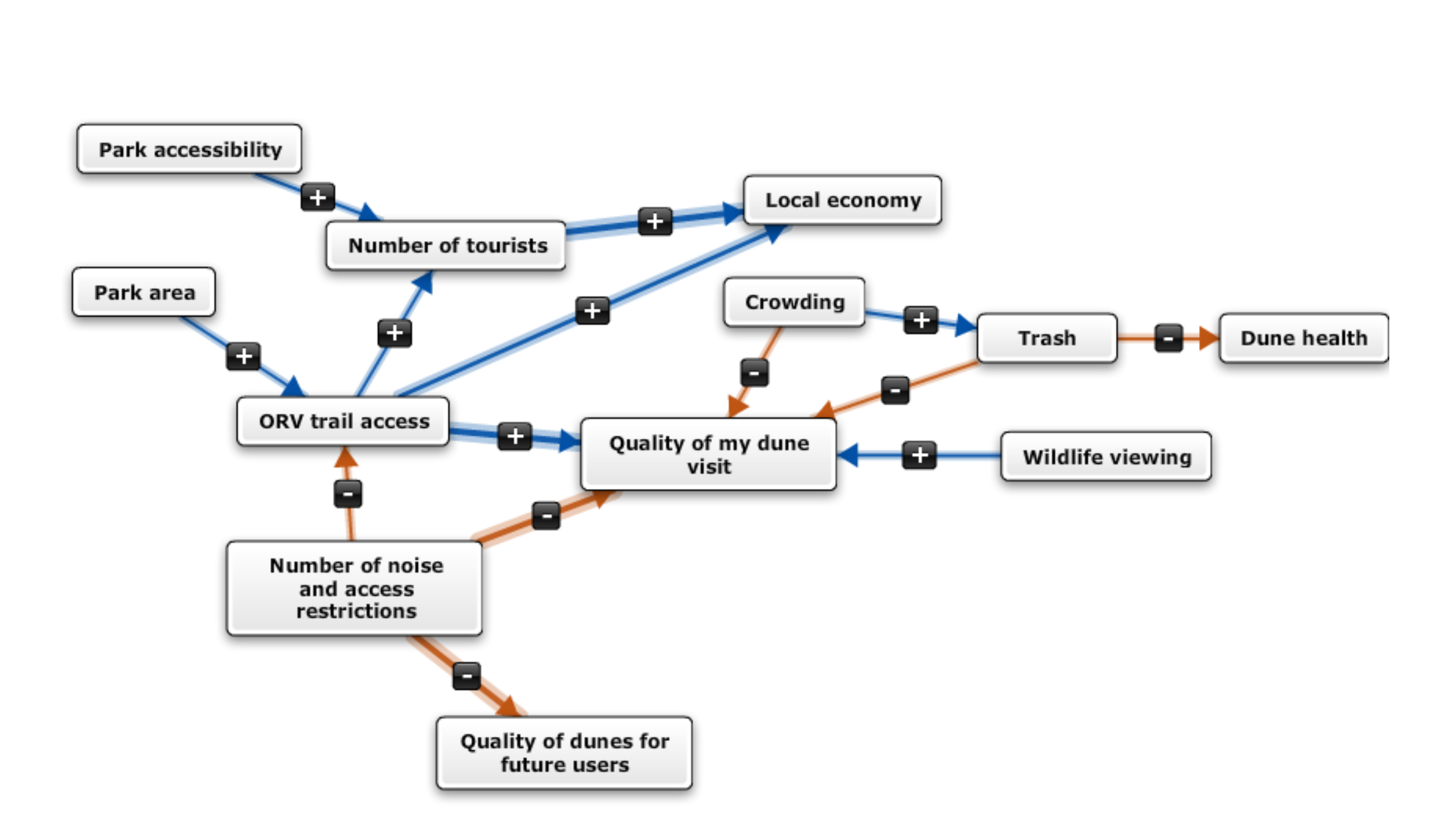
To more deeply investigate perceptions of the coastal sand dunes, four regional modeling workshops were held across Michigan in 2019 with the aim of having participants develop mental maps of coastal sand dunes. In this part of the project, the approach known as mental modeling (or mental mapping) was used to gather information about how citizens and stakeholders perceive the benefits of coastal sand dunes in Michigan, and the threats to the integrity of dunes ecosystems.
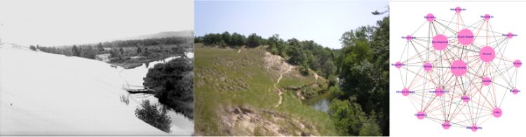
The workshops were held, with the assistance of Laura Young, a master’s degree student in the Department of Community Sustainability, in Douglas, Chikaming Township, Dexter, and Lansing, with 72 individuals participating in total. In these workshops, participants created mental models, or a visual map of the components, or pieces, of a system and how they connect to one another (see image below, an example mental model of Michigan’s coastal sand dunes).
Laura says of the workshops, “They helped participants reflect on their knowledge of dune systems in a unique and interactive way. Between building their own mental models and engaging with Dr. Arbogast, they walked away with a richer understanding of Michigan's world class dunes.”
During the modeling process, participants were given the four terms - access, scenic beauty, dune quality, and development - that emerged from the #howyoudune survey in 2017 as starter components, but were encouraged to develop out their models to show how they thought about the coastal sand dunes ecosystem. What resulted from this process is 72 unique models that represent the range of public perceptions and knowledge about Michigan’s coastal dunes. Finally, Dr. Richardson and colleagues were able to integrate all the individual models into one model that represents the shared perceptions of the coastal sand dunes.
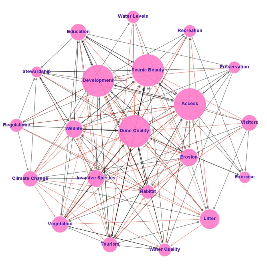
Dr. Richardson says of the modeling process, “The greatest benefit of having these models is being able to now know what is important to our communities. What we’ve learned from this work is people care deeply for the dunes and expressed strong support for protection of the dunes.”
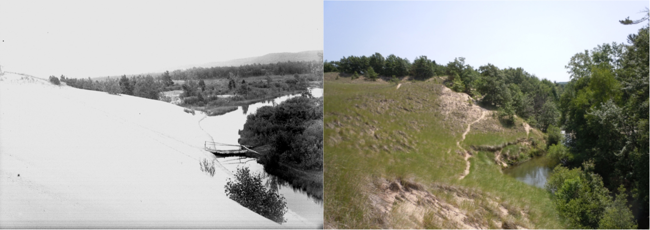
Dr. Richardson’s work adds another way in which to visualize and understand the role Michigan’s coastal sand dunes, complementing the repeat-photography part of the Learning to Live in Dynamic Dunes project. The repeat photography effort was led by Alan Arbogast, professor, and Kevin McKeehan, PhD candidate, from MSU’s Department of Geography, Environment, and Spatial Sciences. The photos were taken at the same location, in the same spot over 100 years apart, showing the transformation of Michigan’s coastal dunes. Together, the photos and the models can help provide guidance to policy makers on the environmental, historic, and cultural heritage value of these coastal sand dunes.
Tom Zimnicki, program director for Michigan Environmental Council, said “The collective ‘we’ needs to do a better job better assisting and helping to inform local township and local municipality planning decisions when it comes to infrastructure along the shoreline.” These reports, Zimnicki said, are the best way to help.
More information on the project can be found on the Michigan Environmental Council's website and in the full report.