Conducting a pre-harvest risk assessment
A major first step in creating a GAP Manual for your farm is to identify the food safety risks – some are obvious, some are not. This article walks you through some of the risks you may not be considering.
A pre-harvest risk assessment is a catalog of all the potential risks to the safety of the food produced on your farm. Not all potential risks are probable risks, but they should be included if for no other reason than to keep you thinking about preventing these risks from becoming realities. If you have ever written an emergency management plan for your farm, the process of writing a pre-harvest risk assessment is similar.
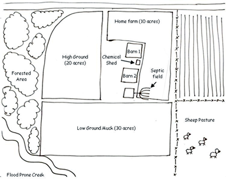
You begin by drawing a map of your farm and the surrounding land features. Be as detailed and specific as you can. Pay particular attention to where livestock operations are in relation to the food production areas. Include areas that can harbor wildlife, such as forested and riparian areas. If the ground is prone to flooding from creek overflows, note that on the map. Be sure to indicate where pesticides and equipment are stored. Any septic fields on the property should also be included on the map. An example map can be seen in the image below.

Photo 1. Example map.
Some growers find using Google Maps to be helpful in visualizing the area around their farms. They may forget that there’s a feedlot less than a mile from one of their far flung fields. The creek running near their low muck ground may not have entered into consideration, but with an aerial photo, it becomes hard to miss.
Once you have assessed your risks, you can alter your growing practices to avoid contamination or implement countermeasures to mitigate the potential threats. In the example shown in the map, the grower may opt not to plant crops in a portion of the low ground on years when the creek floods. This would avoid potential E. coli contamination on any crops grown in the flooded area. The grower may also wish to avoid harvesting the five acres closest to the forested area when evidence of deer and birds in the field are found to decrease the potential contamination of the food.
Always remember to spell out any alteration of growing practices in your GAP Manual. Even if you are actively doing GAP, the auditor won’t give you credit unless there is visual evidence of a food safety practice, documentation in your manual as to your strategy and a record that it has been carried out. Growers with specific questions about Google Maps or having difficulty tailoring GAPs to their farms, are welcome to contact the Agrifood Safety Work Group at gaps@msu.edu or 517-788-4292. To obtain a factsheet on creating a farm map with Google maps, ask for AFSM001-01.
Visit the Agrifood Safety Work Group website:http://gaps.msue.msu.edu/afsm.htm


 Print
Print Email
Email

