Freezing temperatures likely across Michigan
Cold outbreak brings prolonged freeze risk.

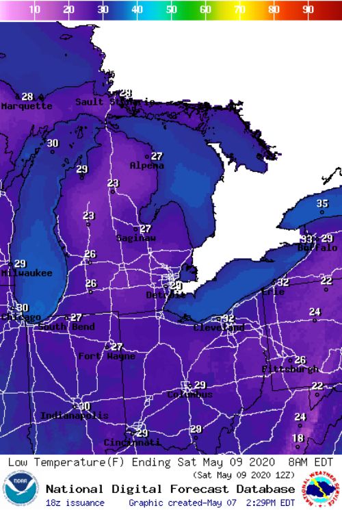
An air mass from the arctic will be moving through Michigan and the Great Lakes region during the next several days, bringing abnormal, potentially record-breaking cold weather to the state with several rounds of subfreezing temperatures through early next week. Coldest readings are expected Friday and Saturday mornings, May 8 and 9, across interior sections of Upper and the northern Lower Peninsulas where the low to mid-20s are possible. Overnight minimum temperatures from the mid- to upper 20s are possible across large sections of central and southern Lower Michigan Saturday morning.
The freeze events expected during the upcoming week will not be quite the same as many other cold outbreaks in the past. Typically during spring freeze events, Michigan is under the influence of high atmospheric pressure with relatively clear, calm conditions near the ground surface, which allow it to cool more quickly than the air above it and collect near the ground. During these so-called radiation freeze events, we usually observe the coldest temperatures in relatively low-lying areas of the landscape where cold air can drain and collect.
During the series of freeze events that are forecast, we are likely to see at least some clouds and wind during the nighttime hours. These types of freeze events are referred to as advective in nature and basically reflect the movement of colder air into a region or area (they are most common in the winter season). From an agronomic perspective, this has both positive and negative implications. On the positive side, the clouds and winds tend to keep the lower atmosphere more mixed up and air temperatures remain somewhat warmer overall than would be the case if it were still. In contrast to the radiation type events, coldest temperatures are usually observed on higher spots on the landscapes that are relatively more exposed to the wind. On the not so positive side, the wind may actually exacerbate the effects of the cold temperatures and cool vegetation and the soil surface more quickly, especially if the temperatures are subfreezing (similar to what wind chill does to humans).
During the upcoming several days, I would look for features of both types of freeze events during the overnight hours (a hybrid type event), with some sheltered areas without clouds and as much wind experiencing some radiative freeze conditions and others, which remain cloudy and windy seeing advective freeze conditions. The impacts, if any, will likely be highly variable across the landscape.
Soil temperatures do follow air temperature patterns fairly closely, so there may also be concern about soils refreezing. From soil temperature observations taken from our Michigan State University Enviroweather network over the years, we can say that it is highly unlikely that 2-inch soil temperatures this time of year would reach freezing during the upcoming events with forecast overnight air temperatures in the mid- to upper 20s for a few hours (mid- to upper 30s soil temperatures are more likely). However, it is possible that a thin, frozen crust may form on the soil surface for a few hours in some northern sections of the state where the temperatures are colder and below freezing for a longer period.


 Print
Print Email
Email
