Improving soil bulk density and carbon estimates in inland wetland histosols
New Project: The Wessel Lab prepares to re-map Michigan wetland soils.
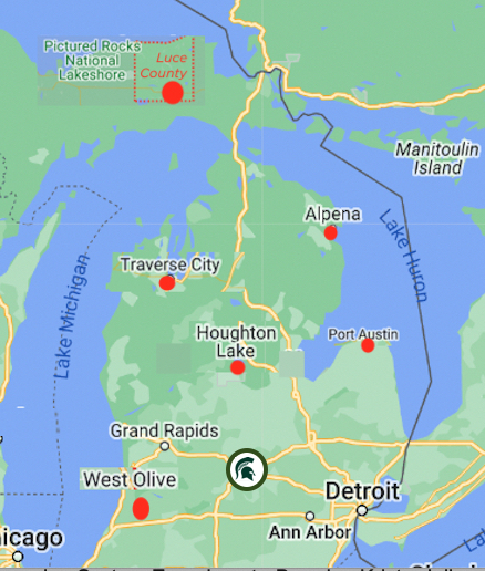
In this new project “Improving soil bulk density and carbon estimates in inland wetland histosols,” funded by the USDA-Natural Resources Conservation Service to support soil survey in the state, assistant professor Dr Barret Wessel and new grad student Bernard Frantz are planning a large-scale sampling tour to collect samples and re-map soil carbon in five Michigan wetland sites that represent the diversity of organic soils in the state.

Map shows approximate sampling locations planned for Michigan. Samples will be kept on campus available for future use.
“It’s a major physical commitment, hand-coring up to 50 cores in a larger wetland,” Wessel says. The team plans to sample 5 sites; the final products will include a report evaluating the accuracy of maps of organic soils.
Wessel and grad student Bernard Frantz will compare the new findings to existing soil survey data outputs, which, Wessel says, “can be based on data that can sometimes date back to around 1900. They have been updated from time to time since then, but earlier projects were not as focused on mapping organic soils or accounting for the amount and forms of carbon that they contain.”
Frantz says This project combines his passions with his studies. “I am taking a mix of wetland, agricultural, and coding classes right now, which all serve to strengthen my fundamentals before we DIG deep into the project,” Frantz says.
The samples will be described and analyzed for soil carbon (total, organic, and inorganic) measured via total elemental combustion analysis (for total carbon) and the Sherrod method (for inorganic carbon, with organic carbon calculated as the difference). Multiple methods will be used to measure bulk density, which is necessary to calculate carbon accounts from the concentration in individual samples. Samples across these sites are expected to be diverse, ranging from fibrous peat to fluid marl, and of course including plenty of Michigan’s muck.
In previous soil survey work, carbon was often measured using older methods including loss on ignition, where the sample is heated to burn off carbon—“A method that can have large errors in certain soil materials, and were only run on selected samples,” said Wessel. “We don’t have a large dataset of historic carbon contents in many Michigan soils, so there is a real need to collect these data.”
These data will enable mappers and modelers to better account for soil carbon stocks in organic soils in Michigan. By having baseline data about current conditions, we can implement programs to, for example, pay landowners to protect or to grow those carbon stocks. Having improved soil carbon data, including soil bulk density measurements, is a necessary prerequisite to the implementation of realistic carbon markets and other tools that could be used to slow and to mitigate climate change.
The samples will initially be stored on campus, though subsamples will be sent to other labs for selected analyses. Excess samples will be available for future testing.
“Organic soils often form in sedimentary environments like bogs and lakes,” Wessel says, “So they can capture environmental signals like heavy metal contamination or pollen that can tell us what was growing in the landscape when a soil layer was formed.”
AS well, the soil team will correlate soil morphologic properties (including hydrogen sulfide odor) with the change in pH and the final oxidized pH of moist aerobic incubation samples. “We are interested in this because of references, dating back about a century, that some wetland soils contain ‘poisonous substances’ that can injure plants,” Wessel says. “I suspect that these are sulfide compounds that are rare enough to have been overlooked in the soil survey, but we’re going to try to find them and resolve that mystery.”


 Print
Print Email
Email


