Northwest Michigan fruit update – May 19, 2026
 Print
Print Email
EmailVariable weather continues across the region, both in temperature and rainfall. There was a relatively narrow window for pollination in cherry with the cold, rain and windy conditions.
Weather report
We have had significant swings in temperatures over the past week. We have dipped down to the 30s and 40s at night, and daytime temperatures reached the 70s and even 80s on Saturday, May 16. Temperature swings of 30-plus degrees have not been unusual. Growers have been trying to navigate sprays with these temperatures, and winds have not made these decisions easy.
We have accumulated 413.5 growing degree days (GDD) base 42 and 191.9 GDD base 50. These accumulations are exactly spot on with our 36-year average of 413.2 GDD base 42. We had gains of close to 100 GDD base 42 and about 70 GDD base 50. This has been the warmest week so far this season, even with the cool to cold mornings.
Rainfall has also been a challenge. The forecasts have been all over the board, and growers have been having a difficult time planning for cover sprays. Predictions are different from the many forecasting options, and the forecasts seems to change often within a day. We have also had some unpredicted rain and thunderstorms pop up across the region. The Northwest Michigan Horticulture Research Center Enviroweather station recorded 0.71 inches of rain on May 12. We received another 0.19 inches on May 16 and 0.9 inches on May 17. There were hard downpours during the May 17 event.
We had more rain on Monday, May 18, where the station recorded 0.41 inches, and we had rain again today, May 19, with an estimated total of 0.14 inches. More rain is in the forecast for later this afternoon. This rain has growers moving to keep up with adequate material on the fast-growing tissue. There have been many fungicide applications made already this week.
Jeff Andresen’s forecast is predicting scattered showers early Tuesday (May 19) and more into the afternoon and evening, mostly in the southeastern part of the state. There is a 65% chance of rain again this afternoon in northern Michigan. Temperatures will drop on Wednesday and Thursday (May 20 and 21), and it will be cloudy. There is a chance of cold temperatures and scattered frost Wednesday night into Thursday morning, but these conditions are predicted further inland. More rain is in the forecast for Friday into Saturday morning, but the weather will gradually warm on Sunday and into next week.
There looks to be a repeat of this week’s weather next week: high temperatures early in the week but cooling into the 50s and 60s on Thursday and Friday. The first weekend of June is predicted to be back into the 70s. The medium range forecast is calling for warmer than normal mean temperatures with near normal precipitation totals for the last part of May.
Crop report
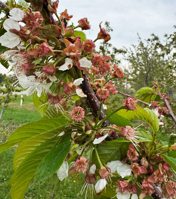
With the recent warm temperatures, we have moved along further in crop development faster this week compared to any other week this spring. With Traverse City and across northern Michigan hitting 80-plus degrees Fahrenheit on Saturday, we seemed to blow through tart cherry bloom so fast. Last week (May 11), we were at early white bud in Montmorency, and on May 18 we were just past full bloom and starting to see first petal fall. With last night’s and this morning’s rains and with the wind picking up, we are at full petal fall today.
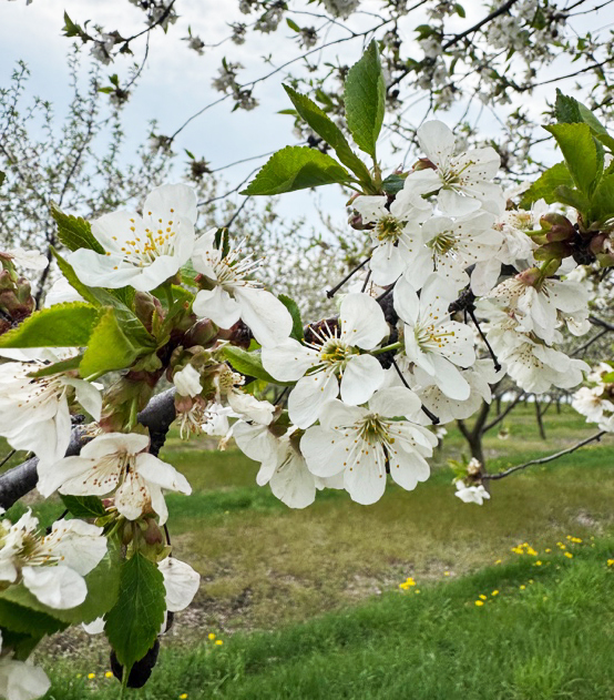
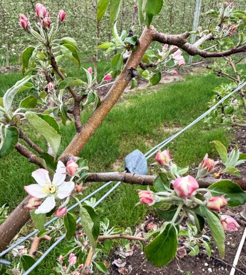
We were just starting to bloom in sweet cherry last week (first bloom to 40%, depending on variety), and now we were at petal fall as of yesterday, May 18. The same situation is in apples: last week we were at early pink, and this week we have king bloom open in Honeycrisp and first king to 40% bloom in Gala.
With the ups and downs in temperatures, sporadic rainfall, stormy weather and winds, the pollination window has been short. We have seen active honey bee hives in the orchard, but activity has typically started to slow in the morning to full on active hives by the afternoon. Rainy weather and high winds will also reduce honey bee activity. However, we did see windows of warm and sunny weather, and we hope these opportunities gave the bees the amount of time they needed to successfully pollinate the crop. Tomorrow is predicted to be cold again with a high of 55 F in Traverse City, and honey bee activity will decrease
Disease report
Apple scab. From pink to petal fall is the time for higher scab inoculum, and growers will need to cover the actively growing tissues following this weekend’s rain and warm weather. Because we see the risk for apple scab increase from pink to petal fall, growers need to be using single site fungicides that have more penetrative activity.
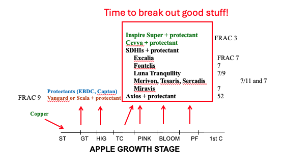
According to the following graph, we have many options for good materials to control scab: Inspire Super, Cevya, SDHI’s (Excalia, Fontelis, Luna Tranquility, Merivon, Tesaris, Sercadis, Miravis) and Axios. These fungicides are also in various FRAC codes, so be sure to rotate materials appropriately to reduce the potential for resistance. At this time, we are in a good situation for controlling scab with the various fungicides with different modes of action—all that are rated excellent against scab. These fungicides will also work against powdery mildew, and at this point in the season, you should be considering materials against this disease.
According to Michigan State University’s (MSU) Enviroweather, we had a moderate scab infection on May 18 with 15 hours of wetting during a span of 20 hours. The average temperature was 66.2 F, and the Northwest Michigan Horticulture Research Center received just under a half inch of rain. As of May 18, we have 81% of the spores matured and 47% of the spores dispersed. We are just under 50% of the spores that are mature and the model is predicting 96% of spores matured on May 25 with 70% dispersed. Growers will continue to manage scab for some time.
Fire blight. Fire blight is caused by the bacterium Erwinia amylovora, an organism that can infect blossoms, fruits, vegetative shoots, woody tissues and rootstock crowns. There are several distinct phases of the disease including blossom blight, shoot blight and rootstock blight. Right now, growers should be actively controlling the blossom blight phase of this disease.
The development of fire blight is heavily tied to weather conditions. For example, pathogen cells grow well at temperatures above 70 F and do not grow well when temperatures are below 60 F. The availability of moisture is important for growth—this moisture can come from rain or heavy dew. Rain also disseminates pathogen cells among blossoms. The fire blight pathogen is adapted to growing on the stigmatic surface of blossom pistils. Populations can readily reach 1 million to 10 million cells per blossom.
Each open blossom is only susceptible to infection for a few days; however, the pathogen is adapted to successfully infect blossoms during this window of time. After explosive growth on stigmas, rain or dew facilitates the movement of pathogen cells to the hypanthium (floral cup) where infection occurs through nectarthodes.
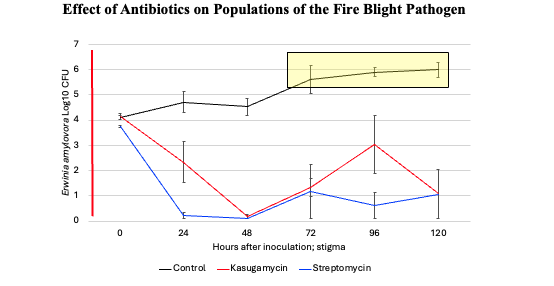
The blossom phase of fire blight is the only phase where the pathogen is located on the surface of trees and can be targeted by chemical sprays. Blossom blight can be controlled by killing pathogen cells on blossoms. The antibiotics streptomycin and Kasumin are the most effective control compounds available for blossom blight; orchards that have streptomycin resistant bacteria need to be relying on Kasumin for fire blight control. In the following graph, streptomycin will keep the bacteria at a lower level for longer than Kasumin, but again, if orchards have resistant E. amylovora, they must rely on Kasumin.
The MARYBLYT model developed by Paul Steiner, PhD is an important tool for growers to assess the potential for fire blight infection. This model, used in conjunction with accurate weather information, is available on MSU Enviroweather and continually assesses the upcoming risk of infection. The MARYBLYT model sets a requirement of four factors that must be reached for a fire blight infection:
- Blossoms open with stigmas and petals intact
- Current average daily temperature above 60 F
- Accumulation of at least 110 cumulative degree-hours above 65 F from the first open bloom
- Wetting event of more than 0.01 inch or heavy dew or fog sufficient to wet foliage or rain of more than or equal to 0.1 inch the previous day.
The MSU Enviroweather model predicts growers should actively manage for fire blight when the epiphytic infection potential (EIP) is greater than 70. The old recommendation to spray for fire blight was when the EIP was greater than 100, but we have reduced that threshold to 70 particularly in susceptible varieties or blocks that have had had fire blight in the past. Michigan State University Extension recommends strep and Kasumin sprays be tank-mixed with acidifier for resistance management, and only spray antibiotics two to three times per bloom to optimize resistance management. Spray before the rain if possible and reapply materials as needed within one to two days if the EIPs remain high.
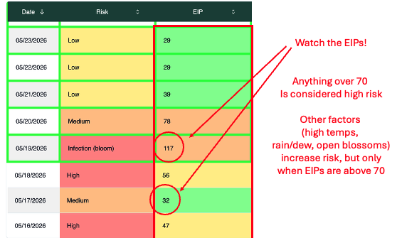
The current forecast at the Northwest Michigan Horticulture Research Center Enviroweather station is showing the risk for fire blight is high at noon on May 19 with an EIP of 150. There is some rain in the forecast for this afternoon, so be sure to put on an antibiotic spray if you have not done so already. By tomorrow, the risk drops to medium and the EIP will drop to 86. This number may drop even lower if the daytime temperature only reaches into the low 50s. By Friday, the EIP is predicted to be 43.
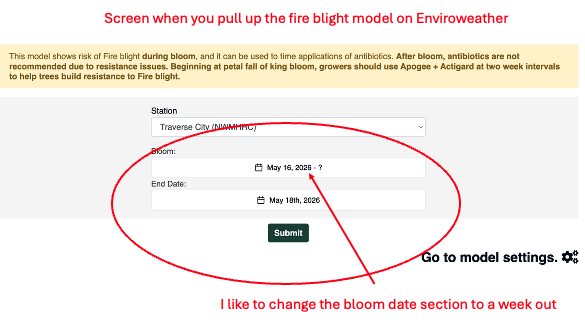
The fire blight model on Enviroweather has changed this season. Contact me if you have questions. When you first click onto the model, there will be three pull down menus: the Enviroweather station, bloom date, and end date. Rather than entering a single bloom date and a single end date into the two drop down columns, we found that if you enter a week of dates into the bloom date pull down, it will provide you with a more expanded look at the fire blight risk rather than looking one day at a time.
After you click submit, there will be a series of two graphs and a table that shows the risk. The first graph is just the EIP by date. If you hover the cursor on the blue line, the EIP changes as you move through time. This feature gives you a look at how the EIP changes through the days as the model uses the forecast data.
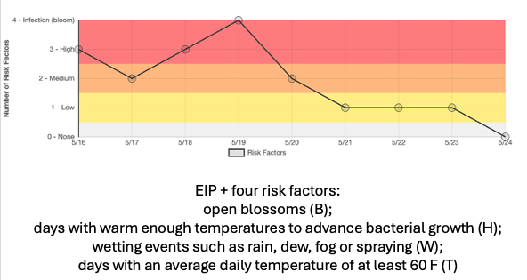
The next chart considers the EIP but also adds the other drivers that impact the risk from fire blight: open blossoms, days with warm temperatures high enough to grow the fire blight bacteria, wetting events (rain, dew, fog), and average daily temperatures above 60 F. When all of the criteria and a high EIP are met, the risk of fire blight increases.
The final chart on the fire blight model output shows the risk in one column and the EIP in another. If you put a week into the bloom date, you can see the risk and EIP over that week (this output is like the old fire blight legacy site model output). You can make decisions as to how the risk factors and EIP change with a look at the whole week rather than one day at a time. Keep in mind that the four other risk factors could be high on the model output, but if the EIP is below 70 (especially well below 70), the risk for fire blight is low.
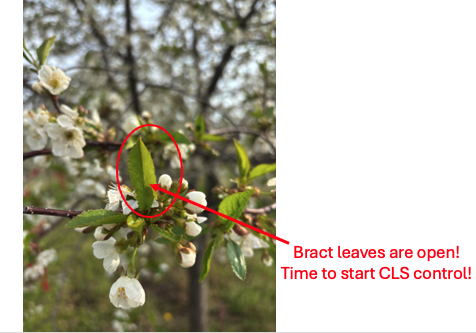
Cherry leaf spot. Growers need to be actively managing for cherry leaf spot: bract leaves are open! The leaf spot pathogen infects through the stomata in the leaves, and the stomata become susceptible when the leaves are open. The cherry leaf spot model on Enviroweather predicted a moderate cherry leaf spot infection on May 18. Chlorothalonil is a good material early in the season. However, this material does not stand up to heavy rainfall, and you will need to cover again if there is significant rain like we had this weekend and into the beginning of the week. The Northwest Michigan Horticulture Research Center has had 1.64 inches of rain since Saturday, May 16.
Also, a reminder that all chlorothalonil products have a 10-day retreatment interval, so this product cannot be used again for 10 days for either every other row or every row applications. Captan is a good product to use now.
American brown rot. We are at petal fall or beyond in sweet cherry at the Northwest Michigan Horticulture Research Center. In our case, we are beyond using Rovral as this material cannot be used after petal fall. We are limited in the products we have to control American brown rot. We recommend saving other American brown rot materials for harvest time when the disease can be more problematic on the fruit.
Insect report
Even with the warm weather this past week, we caught few insects.
Black stem borer. We only caught one this week. We expected an increase in flight over the weekend with the warm weather.
Oriental fruit moth. We caught four in one trap and zero in the other. This is our first catch of this species.
Spotted tentiform leafminer. We caught an average of 14 in three traps.
San Jose scale. We caught two in two traps, and zero in the third trap.
Codling moth. None were caught this week. West central Michigan caught one in their traps this week.
This work is supported by the Crop Protection and Pest Management Program [grant no 2024-70006-43569] from the USDA National Institute of Food and Agriculture. Any opinions, findings, conclusions, or recommendations expressed in this publication are those of the author(s) and do not necessarily reflect the view of the U.S. Department of Agriculture.