Southwest Michigan field crops update – May 13, 2021
Cool and dry weather cleared the way for significant planting progress. As temperatures warm and more dry weather is on the way, concerns arise with crop establishment and early development.
Weather
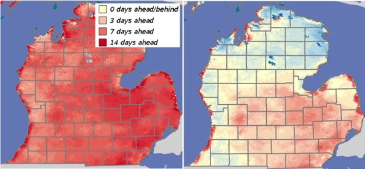
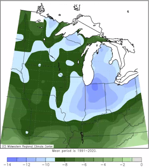
We continue to lose ground with the surplus of heat units we had accumulated earlier in the spring—from being more than two weeks ahead to now being a few days behind in some parts of the region. This last week saw average temperatures from 10 to 14 degrees Fahrenheit below normal. If anyone else had to sit outside watching Little League games in thermals and blankets, you know.
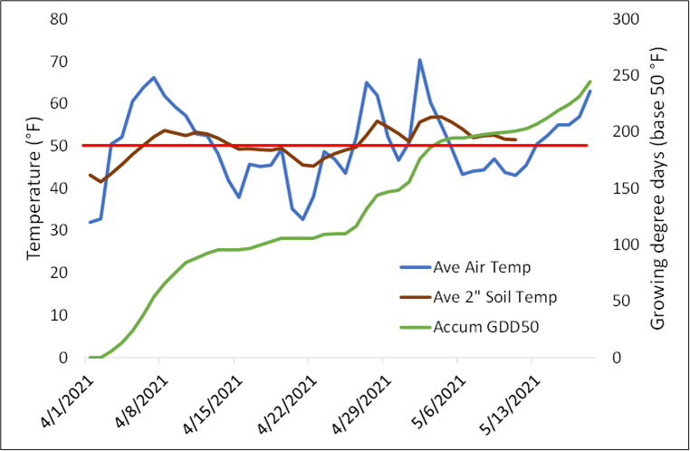
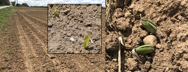
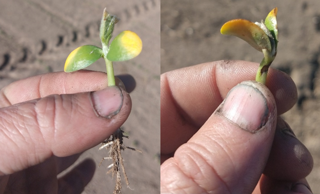
Repeated freeze events over the last week have put a bit of a scare in soybean producers that planted early into near perfect conditions in mid to late April. In many fields, the beans had emerged and some were even to the point of setting the unifoliate leaves. Temperatures dipped to as low as 24 F in the Hartford/Lawrence/Watervliet areas overnight on May 11. Temperatures remained below 28 F for 3-4 hours at the Michigan State University Enviroweather stations near these locations. Undoubtably, there were lower temperatures experienced in lower lying fields in some of these areas. Exceptionally dry conditions and low humidity levels most likely played a role in the localized temperatures in fields.
There are some areas in fields that did have damage that would most likely trigger a “patch in” replant in fields. However, in most cases, these early planted soybeans are likely to come through the freezes remarkably well. Michigan State University Extension soybean educator Mike Staton wrote an excellent article on how to assess freeze damage to soybean plants in early spring. If you have soybeans that were up and you are trying to access the damage, we encourage you to review this article.
Average 2-inch depth soil temperatures remained above 50 F despite the cool temperatures, and they should not be a concern for the rest of the planting season. Currently, the weather outlooks for mid-May are calling for warmer-than-normal temperatures, and Jeff Andresen, the MSU Extension agriculture climatologist, says we have very likely seen the last of our overnight freezing temperatures as the forecasted daily highs return to 60s and 70s and nighttime lows stay in the 50s starting this weekend.
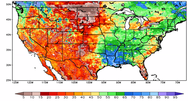
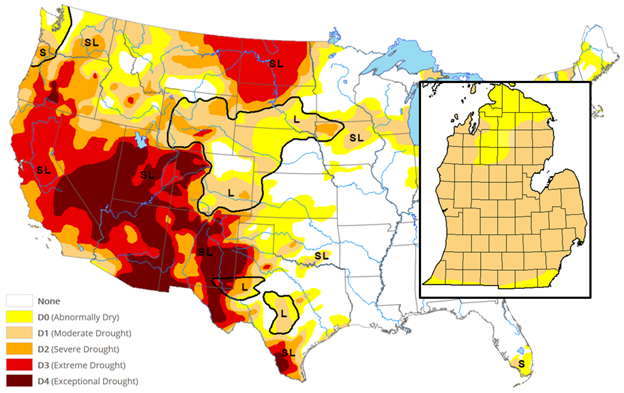
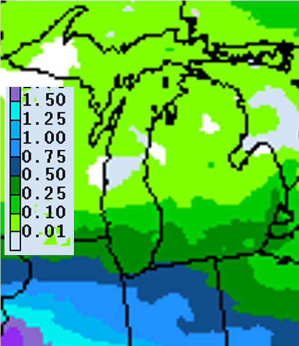
The southwest region has also continued to be well below normal with precipitation as recent weather systems have kept the moisture just to our south. Most of the region has received 20-75% of normal precipitation in the past two weeks, and soil moisture is 30-45% in the top 3 feet. The current edition of the U.S. Drought Monitor shows a slight lessening of the moderate drought conditions for the southern border and the upper Lower Peninsula. The cool temperatures have kept evaporative demand fairly low, but this will change as temperatures begin to warm with the forecasted reference evapotranspiration rate at just over 1 inch for the coming week.
The forecast for the coming week calls for another dry week with 0.5 inches rain or less throughout the region. The medium-term forecast changed significantly in the past two days from warmer and wetter than normal to warmer and drier than normal as a particularly strong upper air ridge has formed.


Crops and pests
Wheat is currently at the jointing stage in our area, although one field scouted had flag leaves emerged. Only minor Septoria signs were seen in the lower canopy in a couple of fields. Herbicide and nitrogen applications should be completed before the flag leaf emerges to avoid injury to this important source of photosynthates for the developing head. The publication “Fungicide Efficacy for Control of Wheat Diseases” from the Crop Protection Network lists several fungicides and their efficacy against several wheat diseases along with harvest interval restrictions.
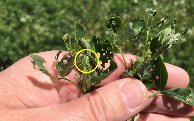
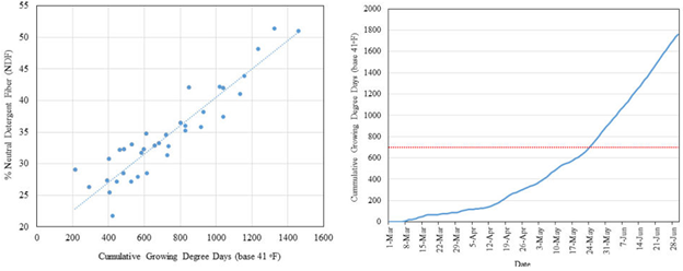
Alfalfa is currently in the late vegetative stage and appears healthy overall. However, a concern for this spring continues to be the early development of alfalfa weevil which has begun increased foliar feeding in many fields in Indiana and Michigan. Scouting should begin now, and first hay cutting may be impacted as alfalfa growth slowed down with recent cooler temperatures. Current average GDD41 accumulation in the region is 510 with another 110 forecasted for the coming week. At that pace, first harvest should be timed for the last few days of May, but scouting individual fields for bud development and knowing your past forage quality values will help dial this in.
Corn planting progress is well ahead of the average. According to the May 10 USDA Crop Progress report, 46% of the corn crop in Michigan has been planted—13% ahead of last year and 27% ahead of the five-year average. Soybean was 42% planted—10% ahead of last year and 31% ahead of the five-year average. Corn is 5% emerged and soybean 4%, but that was as of May 9—we suspect by now it is two to three times that. It takes approximately 100-120 GDD from planting for these crops to emerge, and early planted corn and beans began to emerge this week in several fields in the area.
Corn looks yellowed, which is normal for early season emergence in cool conditions, but this should fix itself when temperatures warm up, especially if we get some much-needed rain or when irrigation is applied.
Dry conditions this spring are likely to have some other impacts on crops as well. Those still planting corn should be cautious about the amount of starter fertilizer they place in the 2x2 configuration in light textured soils. Salt in higher rate starter fertilizer applications can cause injury because they will likely make up a larger percentage of the soil moisture that the developing plants have access to. A couple things to consider might be to remove any potassium that is being applied as a starter. In addition, you might want to consider limiting your nitrogen (N) application rate to about 40 pounds N per acre. The remainder of the N can be applied sidedress with little risk of yield reductions.
Another issue with the dry conditions can be the lack of moisture for even germination. Staton also discussed some potential planting depth options for soybeans given the low soil moisture we are seeing in many parts of the southwest region. Reducing the number of field preparation operations or planting no-till where possible can help reduce water loss from the soil due to evaporation.
And finally, we count on rainfall to help activate soil applied preemergence or delayed residual herbicide programs. We probably need to be prepared to include a post program if the dry conditions continue and applied herbicides remain on the soil surface for extended periods of time (10 days or more). This may continue to be problematic as some herbicides are in shorter supply this year.
If you have access to irrigation water, irrigating early can help to reduce the risk of all of the situations mentioned above. MSU and Purdue irrigation educator Lyndon Kelley discusses this in his article, “Water up and irrigate in”. With warmer weather in the forecast, it appears we may be able to irrigate without having to drain the systems for fear of freezing the pipes.
Asiatic garden beetle grub scouting by MSU field crops entomologist Chris DiFonzo at the Decatur, Michigan, research site located on Druskovich Farms on Wednesday, May 12, resulted in very few sightings. She suspects soil temperatures are still too cold for the grubs and that they have not moved up in the profile yet, but that will change in the coming week. With the dry conditions, we may have a situation where if you do have Asiatic garden beetle in higher numbers, the white grub damage may be able to injure the plants more because of the anticipated slower growth rates of the corn.
Remember, the higher risk areas seem to be fields that were rotated from potatoes or soybeans in 2020. Focus your attention on higher elevation sandier portions of fields that had high numbers of weeds in the field last season, especially marestail.
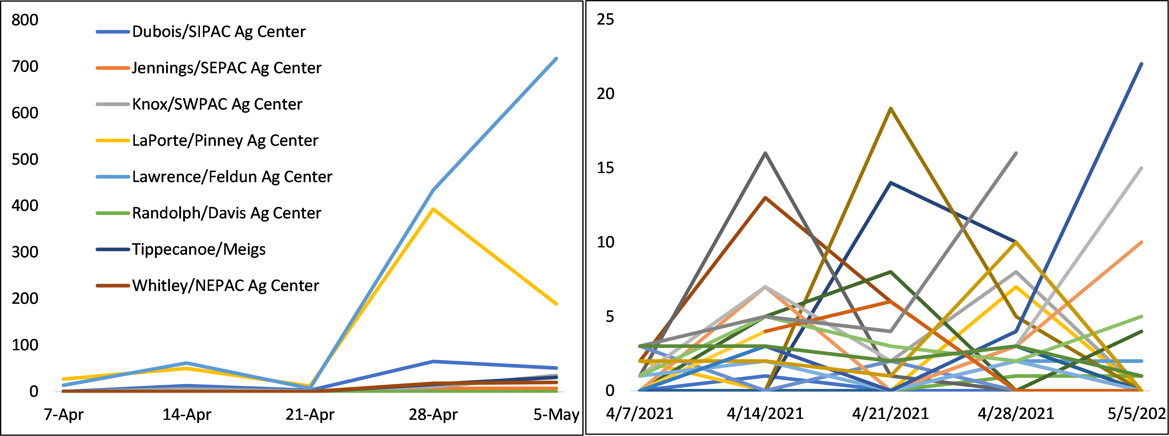
True armyworm and black cutworm moth captures remain low in the region with all traps still catching single-digit numbers of moths in St. Joseph and Kalamazoo counties. This is likely due to a lack of significant storm systems out of the south that have made it very farm into Michigan. Purdue traps have had sporadic high counts although no peak flight timeframe has been identified yet.


 Print
Print Email
Email