West central Michigan tree fruit update – June 3, 2025
 Print
Print Email
EmailAfter some very cold nights, warm weather is a welcome change this week.
Weather update
This week’s weather is notably warmer than last week. With cool nights over the past 7–10 days, some growers ran frost fans to protect fruit in the west central and Grand Rapids regions—particularly on the morning of June 1, when temperatures dipped into the low 30s across the region. Warmer day- and nighttime temperatures this week are a welcome change.
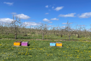
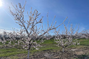
Fruitlets are growing steadily, about 0.5 to 1 millimeter (mm) per day. Tart cherry, sweet cherry and peach have set well in many orchards across the region. Apples and pears are sizing well, and some varieties, such as Gala, have a heavy set in many orchards (see Figure 1).
Average temperatures this week will be much warmer than last week and more typical for this time of year. Highs for June 3 across the region will be in the low 80s. The rest of the week will be slightly cooler, with highs in the upper 60s to low to mid-70s. Nighttime temperatures will be much warmer than in past weeks, with lows in the upper 40s to mid-50s, according to the Hart and Sparta Enviroweather stations.
Cool temperatures have kept phenological development slow and steady until now; however, this week should bring faster fruitlet growth, increased canopy development and greater fruit respiration rates.
As of June 3, the Hart Enviroweather station reported current degree day (DD) accumulation at 681 DD42 and 324 DD50. The Sparta station reported 843 DD42 and 437 DD50. Degree day accumulation remains below the five-year average for both the west central (Table 1) and Grand Rapids (Table 2) regions.
For the next few days, expect warmer and windy conditions with chances of rain Tuesday and Wednesday. Evaporative demand will be high in orchards this week.
Get the full weather update from Jeff Andresen
Table 1. West Central Region: Current and Five-Year Average DD Summary from Jan. 1-June 2. Numerical integration was used for degree day calculations.
|
Station |
2025 DD Base 42 F |
5-yr Avg DD Base 42 F |
2025 DD Base 50 F |
5-yr Avg DD Base 50 F |
|
Benona/Shelby |
619 |
754 |
285 |
393 |
|
Elbridge/Hart |
717 |
814 |
362 |
443 |
|
Fremont |
780 |
878 |
405 |
483 |
|
Grant |
844 |
902 |
447 |
501 |
|
Hart |
681 |
799 |
324 |
427 |
|
Ludington |
654 |
758 |
304 |
402 |
|
Mears |
671 |
793 |
316 |
423 |
|
New Era |
692 |
822 |
329 |
438 |
|
Shelby-East |
714 |
820 |
347 |
443 |
Table 2. Grand Rapids Region: Current and Five-Year Average Degree Day Summary from Jan. 1-June 2. Numerical integration was used for degree day calculations.
|
Station |
2025 DD Base 42 F |
5-yr Avg DD Base 42 F |
2025 DD Base 50 F |
5-yr Avg DD Base 50 F |
|
Sparta |
843 |
910 |
437 |
502 |
|
Alpine Twp/ Comstock Park |
862 |
933 |
448 |
516 |
|
Sparta-North |
834 |
917 |
426 |
504 |
|
Conklin/Wright |
843 |
940 |
431 |
520 |
|
Kent City |
814 |
909 |
415 |
503 |
|
Standale/Walker |
901 |
982 |
479 |
554 |
|
Belding |
840 |
914 |
434 |
510 |
|
Clarksville |
889 |
941 |
461 |
523 |
Weather data was gathered from Enviroweather.
Rain during storms last week improved soil moisture across west Michigan. From May 20–22, precipitation totaled 2.03 inches at the Hart Enviroweather station and 0.90 inches at the Sparta Enviroweather station.
On June 2, the Hart Enviroweather station recorded a maximum soil temperature of 68.8 degrees Fahrenheit at 2 inches depth and 65.1 F at 4 inches. These temperatures had dropped to the low 60s during the previous week’s cooler weather. Optimal root-zone soil temperatures are approximately 64–77 F. Maximum soil moisture at 4 inches was 9.6%, and at 20 inches was 8.3%.
At the Sparta Enviroweather station, the maximum soil temperature on June 2 was 67.8 F at 2 inches and 64.5 F at 4 inches. Maximum soil moisture was 47.5% at 0–12 inches and 54.6% at 12–24 inches, slightly lower than last week.
More information and reports on normal weather conditions and departures from normal can be found on the NOAA Climate Prediction Center website, NOAA U.S. Climate Normals website, NOAA Climate Normals Quick Access Page (which may be searched by region) and Midwest Regional Climate Center website.
Crop update
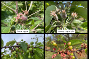
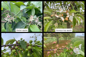
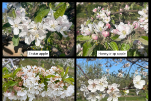
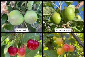
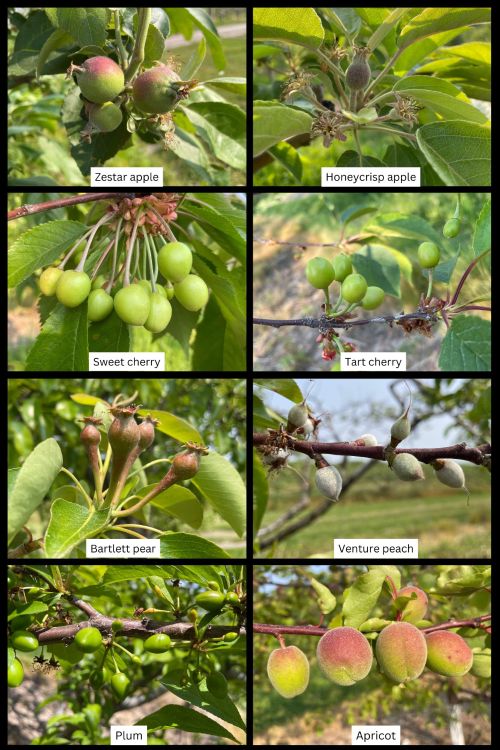
Apple varieties in Oceana County range from petal fall with some straggling bloom near the lake shore to 15-19 mm for early varieties. Zestar have an average fruitlet size of 17 mm, and average Idared fruitlet size is 16 mm. Later varieties such as Gala and Honeycrisp are at fruit set with king fruit at 12 and 10 mm, respectively. There is a wider range of phenological stages on trees this season, which is likely due to changes in temperature with mixed conditions of warm then cool temperatures. This may be helpful for thinning as the largest fruit in the cluster will be more competitive than smaller fruitlets, and the smaller fruitlets will be more affected by chemical thinner.
Weather conditions will be good for chemical thinner applications this week. The Cornell Apple Carbohydrate Thinning Model shows that Hart has a slight carbohydrate deficit for the 6-day weighted average predicted for June 3. The model suggests that thinning efficacy will be good. If you look at the carbohydrate balance graph, the trend of the carbohydrate status has gone down over the past few weeks and is now slightly below the balance for 6-day average threshold of 0 for Hart and just above the 0 threshold for Sparta. On June 3, the calculated 6-day average is -4.91 for Hart and 0.56 for Sparta.
As a reminder from last week’s article, this timing is important physiologically as trees are using up their carbohydrate reserves and new leaf tissue has not started supplying all the carbohydrates needed for developing fruitlets. Similar to last week, this is a “sweet spot” for thinning time and is when fruitlets are most sensitive to chemical thinners. After this timing, shoots that are about 12 inches long or more will begin supplying carbohydrates to the tree which generally occurs when fruitlets are about 15 mm. This new supply of carbohydrates from actively growing shoots makes fruitlets less responsive to thinners.
According to the Apple Thinning Guide from Michigan State University Extension, the thinning sensitivity is low at pet fall, greatest at 10 mm, and then quickly becomes insensitive as the 25 mm stage is approached. The thinning response is also driven by the weather at the time of thinning. Hot cloudy conditions at any of these stages will promote thinning, and under cool and sunny weather, thinners will be less effective. This week is a great window for thinning. If thinners are needed, do not miss this application timing.
There is variation in fruit set this year by block and by variety. For blocks with heavier fruit set, higher rates of thinner applications may be needed because there is a lot of new leaf growth currently. Oil can also be added to enhance the thinning response if needed; however, if nighttime temperatures are around freezing or if captan has been used recently for disease management, oil should not be used because it can cause phototoxicity and tissue damage.
There have been some reports that varieties, such Fuji and Honeycrisp, have lower fruit set this year, but that is highly dependent on orchard block and cropping history. Other varieties, such as Gala and Idared, have adequate fruit set. Scout orchards block by block to determine if a chemical thinner is needed. It is important to scout orchards on foot this season. There is more foliage now than is typically seen at thinning time, and it is difficult to see fruitlets that are there without close inspection. Also look throughout the canopy as fruit set is often higher in the top of the tree compared to the bottom.
It is important this year to measure fruit daily or every few days to determine if fruit are continuing to grow or if they stop growing. With cool temperatures, fruit size has not seemed to differentiate for some varieties making it difficult to visually identify what fruit will stay and what fruit will abscise. Use the fruit growth rate model to determine fruit set and efficacy of thinner applications. As a reminder, fruit that continue to grow steadily will persist, and fruitlets that are growing at a rate of 50% or less than the fastest growing fruit will abscise.
Learn more about the fruit growth rate model.
Sweet cherry are growing steadily with good fruit set for varieties such as Black Pearl, Ebony Pearl and Regina in some orchards. Average fruit size is 14 mm for sweet cherry. Average fruitlet size for tart cherry was 12 mm.
Peaches are out of the shuck and fruit set looks adequate this year for many orchards. Venture peach at the West Central Michigan Research and Extension Center had an average fruitlet size of 9 mm.
Apricots are growing steadily, and average fruit size is 27 mm in Oceana County.
Plums are out of the shuck for European and Japanese varieties. Stanley plums measured at 10 mm on average.
Pear fruitlets are growing steadily and differentiating in a cluster. Average fruitlet size was 12 mm for Bartlett pear at the West Central Michigan Research and Extension Center.
Pest and disease update
Diseases
Cooler weather slowed insect activity last week but this week’s warmer weather will enhance insect activity over the next few days, especially for pests like plum curculio, oriental fruit moth and codling moth. There will be risk for apple scab and cherry leaf spot this week, and the warmer temperatures means higher infection risk. The Enviroweather apple scab model for Hart and Sparta is predicting that 100% of spores are mature and 90% of spores have been released in Hart and 95% of spores have been released in Sparta.
Bacterial canker symptoms are showing up this week with lesion development on fruit and leaves. The best approach for managing bacterial canker is to prune out dead, decaying wood and cankers during a stretch of dry weather.
Insect pests
In Oceana County, no green fruitworm or red banded leafroller were caught. Oriental fruit moth was trapped with an average of one moth per trap. With a biofix of May 5, peak egg-laying is expected June 5.
American plum borer was trapped at the West Central Michigan Research and Extension Center (0.3 moths per trap) and in Mason County. Lesser peach tree borer was trapped in Oceana and Mason counties. Plum curculio have been trapped throughout the state, and with warmer temperatures forecasted for later this week, they will likely be laying eggs and feeding in orchards. No damage has been observed in apricot, tart cherry and sweet cherry scouting.
Codling moth was trapped for the first time at the MSU trapline, although there have been reports of codling moth catch at other sites over the past few weeks in Oceana County. Codling moth were also trapped in Mason County. No lesser apple worm were caught.
Grand Rapids area integrated pest management report
The following was provided by Amy Irish Brown, Valent USA, June 2, 2025.
Tree fruit diseases
Cool temperatures continued through the end of May with widespread rain occurred across the Grand Rapids area, May 28-29.
Primary apple scab continues, but the end is near. The last rain event on May 28 resulted in nine spores released per rod and while this number is low, relative to the whole season, it is still significant. The highest spore number for the season was 542 on May 1, so primary if very much still on for at least another week. Primary spores should be fully or almost all mature, and it typically takes one or two daytime rains to discharge them all.
The higher humidity and warmer temperatures this week will once again increase the likelihood for powdery mildew, especially if mildew got a foothold during bloom when it last was warm and conducive to this fungus.
It’s been nearly three weeks since bloom and the extreme fire blight infections during bloom. Normally it takes nine or 10 days to see flagging from fire blight, but the very cool weather has slowed disease expression. This will be the week and next will be important to be watching for any shoot collapse around fruit clusters. I can’t remember a prior year where it’s taken this long to get through the blossom blight symptom model.
Tree fruit insects
Heavy rains since petal fall applications increase the need for insecticide cover sprays especially now that warmer weather has reappeared. I wouldn’t be surprised if plum curculio females still have plenty of eggs to lay, and they could be very active this week in the warmer temperatures, and significant damage could result later than expected. We are approaching timing for early egg hatch of codling moth and cover sprays are needed in apple blocks over threshold. There are a few reports of black stem borer infestation in grafted apple trees. Shoot tip flagging in peaches from oriental fruit moth could present this week. Cover sprays need to be maintained for a few weeks still. Dogwood borer will begin flight soon; time to get mating disruption in place in blocks that need it. Remember, dogwood borer disruption does not need to be hung high in the tree—chest or eye level is fine.
For more information about regional reports, please visit the Michigan State University Extension website.
This work is supported by the Crop Protection and Pest Management Program [grant no 2024-70006-43569] from the USDA National Institute of Food and Agriculture. Any opinions, findings, conclusions, or recommendations expressed in this publication are those of the author(s) and do not necessarily reflect the view of the U.S. Department of Agriculture.